It's a Marathon, not a sprint: Small steps build lasting momentum for comprehensive restoration
By Estelle Robichaux, Restoration Project Analyst, Environmental Defense Fund and Gaby Garcia, Science Intern, Environmental Defense Fund
This post is part of a series on early restoration planning in Louisiana. Be sure to check out parts one and two for more information on previous plans.
By the early 1990s, Louisiana’s coastal land loss crisis had been studied and documented for more than two decades. Successful establishment of the state-level Office of Coastal Restoration and Management and the Wetlands Trust Fund in 1989 galvanized support and action for wetlands restoration at the federal-level as well. In 1990, Louisiana U.S. Senator John Breaux co-sponsored and helped pass the Coastal Wetlands Planning, Protection and Restoration Act (CWPPRA), sometimes called the “Breaux Act.”
The Act was one of the first attempts to support a comprehensive approach to restoring Louisiana’s coastal wetlands by establishing a dependable, long-term funding stream for projects. A new federal interagency task force, made up of five federal agencies and the Louisiana state government, was also created by the Act to oversee coastal restoration activities, including the prioritization, planning and implementation of small- to medium-scale projects.
Three years after CWPPRA was enacted, in 1993, the Task Force published their Louisiana Coastal Wetlands Restoration Plan, which recommended changes in management of the lower Mississippi and Atchafalaya Rivers. The plan focused specifically on increasing the sediment and freshwater supply to coastal wetlands to reestablish natural land-building processes.
The CWPPRA plan only has a 20-year time horizon, as opposed the 50-year perspective taken in other contemporary plans published by the Louisiana Governor’s Office of Coastal Activities, the Louisiana Department of Natural Resources (LDNR), Louisiana State University or the 2012 Coastal Master Plan. Despite the shorter outlook of the CWPPRA plan, it relies on similar principles and strategies we see in these other plans. Namely, this plan calls for:
- Shifting navigational use from the existing bird’s foot delta to a new western delta in a neighboring estuary, possibly Breton Sound;
- Multiple diversions to address land loss in Barataria Basin;
- Reactivation of old distributary channels;
- Seasonal changes in the Atchafalaya River’s flow distribution; and
- Projects to facilitate hydrologic restoration, such as: Nourishing barrier island chains and Controlling tidal flows in large navigation channels.
Small scale tests, important success
Even before the passage of CWPPRA, the LDNR was implementing small-scale diversions by cutting crevasses into banks of the southernmost reach of the Mississippi River. Between 1986 and 1993, 20 crevasses were constructed with a mean discharge rate of less than 4,000 cubic feet per second (cfs). Despite the lower flow rates, these crevasses created nearly 1,400 acres of emergent marsh during this period, an impressive amount of land considering the scale of these projects.
The early results of these experimental projects encouraged the prioritization of sediment diversions in the CWPPRA planning process, many of which have also performed well. The Channel Armor Gap Crevasse, for instance, was constructed in 1997 in one of the most rapidly subsiding areas of the delta. This crevasse created nearly 200 acres of land over 10 years and increased overall sediment elevation by more than three feet.
The West Bay Sediment Diversion, on the other hand, was constructed in 2003 and had formed little subaerial land despite the creation of two small spoil islands in the bay in 2009. Due to this lack of land building, it was considered a complete failure and was in the process of being deauthorized. But after the historic flood of 2011, which delivered large quantities of sediment to coastal Louisiana, dry land had emerged in West Bay by that fall. This combination of spoil islands and pulsing floodwaters has proven successful in building land here and may be translated elsewhere across the coast.
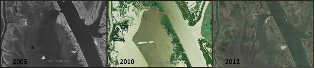
West Bay Sediment Diversion
Scaling up the vision for restoration
CWPPRA has played an important role in funding restoration projects, beyond diversions, across the coast. The program has also been critical in supporting long-term, large-scale undertakings, such as the Coast-wide Reference Monitoring System and planning efforts like the Barrier Island Shoreline Feasibility Study and Coast 2050.
The Barrier Island Shoreline Feasibility Study was the first large-scale feasibility study sponsored through CWPPRA. The technical analysis, completed in 1997, was designed to figure out the most effective barrier island configurations to protect inland areas from saltwater intrusion, wind and wave action, storm surge and other extreme events, such as oil spills. An estimate of the possible quantitative effects of different regional barrier island arrangements on Louisiana’s environmental and economic resources were produced through this work as well.
The scope of the study was limited to the shoreline from the Atchafalaya River east to the Mississippi River and provided two alternatives for restoration. These results ultimately informed the initial Barrier Shoreline Restoration studies conducted as part of the Army Corps’ Louisiana Coastal Area (LCA) Ecosystem Restoration Study, which in turn formed the basis for two of our priority projects, Barataria Pass to Sandy Point and Belle Pass to Caminada Pass Barrier Island Restoration.
While the CWPPRA Plan proposed some forward-thinking solutions at the basin-wide level to mimic natural processes, Coast 2050 took comprehensive planning even further. This initiative, finalized in 1998, was jointly developed by the Louisiana State Wetlands Authority and the CWPRRA Task Force and takes a regional perspective on restoration strategies for long-term ecosystem sustainability. The LCA Ecosystem Restoration Study was largely based on the recommendations and vision of Coast 2050, both of which played a significant part in shaping the 2012 Coastal Master Plan and the way we envision restoration in coastal Louisiana.
Be sure to check out our next post for more details on Coast 2050 and the Louisiana Coastal Area Study!
You can show your support for coastal restoration by taking the pledge to urge leaders to be a powerful voice for coastal restoration. Take the pledge at RestoretheCoast.org!